
Seismic liquefaction assessment in Calabria (Southern Italy): a geostatistical approach at regional and sub-regional scale
- 25 Febbraio 2022
- Pericolosità, Pubblicazioni
Autori: Rose Line Spacagna1, Attilio Porchia1, Stefania Fabozzi1, Massimo Cesarano1, Edoardo Peronace1 & Gino Romagnoli1
Affiliazioni:
1 Istituto di Geologia Ambientale e Geoingegneria – Consiglio nazionale delle Ricerche (CNR IGAG).
2022 ITALIAN JOURNAL OF GEOSCIENCES
Abstract
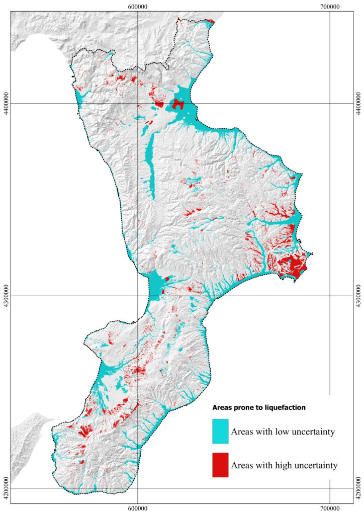
Seismic liquefaction assessment at different geographical scales provides hazard maps at increasing levels of resolution and reliability. According to the considered level, the areas prone to liquefaction are identified based on specific predisposing and triggering factors, including geological and geotechnical subsoil properties and local seismicity. The robustness of the definition of these areas is strongly correlated to the availability and spatial distribution of this information. Moreover, the data type and quality considerably influence the method of analysis and the degree of uncertainty of the results. This work proposes a methodological approach to define maps in terms of liquefaction susceptibility at two different geographical scales (i.e., regional and sub-regional scale). The Calabria region in Southern Italy was studied for the scope, characterised by a relatively high level of seismicity and liquefaction occurrences recorded during the numerous historical earthquakes. At the regional scale, the level of zonation represents a preliminary assessment of areas potentially susceptible to liquefaction. The considered predisposing factors and geospatial variables were implemented from approximately 5520 available surveys, using geostatistical tools to filter inconsistent data and quantify uncertainties. A quantitative assessment of the liquefaction predisposition was also proposed at a sub-regional scale in the identified areas prone to liquefaction. A new proposal of a Territorial Liquefaction Predisposing Index was carried out by quantifying the uncertainty due to the limited availability of data with geostatistical methods. This approach could provide helpful information for land management and emergency planning to characterise the territory for liquefaction instability and optimise resources allocation to reduce the level of uncertainty at higher levels of analysis.
Parole chiave

CONTRATTO CONCERNENTE L’AFFIDAMENTO DI SERVIZI PER “PROGRAMMA PER IL SUPPORTO AL RAFFORZAMENTO DELLA GOVERNANCE IN MATERIA DI RIDUZIONE DEL RISCHIO SISMICO E VULCANICO AI FINI DI PROTEZIONE CIVILE NELL’AMBITO DEL PON GOVERNANCE E CAPACITÀ ISTITUZIONALE 2014-2020”– CIG 6980737E65 – CUP J59G16000160006
Copyright © 2017 - Progetto grafico e sviluppo Heap Design