
Multiscale geothematic maps for using the database from the Italian Seismic Microzonation Project: an example of application in the Calabria Region (Southern Italy)
- 25 Febbraio 2022
- Pericolosità, Pubblicazioni
Autori: Massimo Cesarano1, Attilio Porchia1, Gino Romagnoli1, Edoardo Peronace1, Amerigo Mendicelli1, Marco Nocentini1, Giuseppe Naso2, Sergio Castenetto2, Stefano Catalano1,3 & Massimiliano Moscatelli1
Affiliazioni:
1 CNR-IGAG, Istituto di Geologia Ambientale e Geoingegneria, Area della Ricerca di Roma 1, Via Salaria km 29.300, 00015 Rome, Monterotondo, Italy.
2 Presidenza del Consiglio dei Ministri – Dipartimento della Protezione Civile (DPC), via Vitorchiano 2, 00189 Rome, Italy.
3 Dipartimento di Scienze Geologiche, Universit di Catania, Corso Italia 55, 95129, Catania, Italy.
2022 ITALIAN JOURNAL OF GEOSCIENCES
Abstract
This work is part of a broader project that aims to define a methodology for assessing the local seismic response on a large scale through a series of cognitive phases. Here we present the first phase that illustrates a procedure for the creation of standardised geothematic maps, at a national, regional and sub-regional scale, showing the geological and engineering-geological features that potentially induce stratigraphic amplification of the ground seismic motion.
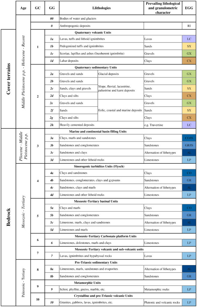
The main goal is to create a national reference legend to adopt, at different scales and detail, for complete coverage of the national territory. The method consists of consecutive steps that can be followed to obtain more detailed documents, starting from national scale geological maps, taking into account all the possible geological contexts characterising the Italian Peninsula. The first step is the reclassification of the lithostratigraphic units from the most detailed, reliable and updated available geological maps, in order to compose homogeneous geological and engineering geological maps at national scale.
The construction of the legend and the elements contained in it plays a fundamental role in the process and constitutes the reference for more detailed maps at larger scales. We consider the age and the genetic domain to identify 10 main geological categories and from these, considering the prevailing lithological characters, to distinguish 27 geological groups. The engineering-geological map at national scale derives from the combination of the geological groups with the engineering-geological groups, representing the main characters of the cover terrains on the base of the main grain size and the geological substratum categories, adopted in the seismic microzonation studies (Technical Commission for Seismic Microzonation, 2020). At regional and sub-regional scale, we reclassified a more detailed geological map to convert it in an engineering-geological map of territorial context, characterised by the engineering-geological units adopted in the seismic microzonation studies of Italy. In order to reconstruct all the possible stratigraphic columns in term of the engineering-geological units in the territorial context representative of the shallower subsoil (< 50 m in depth), we proposed a representation in matrix form that combines the outcropping engineering-geological units with the units of the subsoil. Where seismic microzonation studies are not available, the multiscale engineering-geological maps could represent a useful tool for the seismic hazard assessment for the territorial planning at regional and sub-regional scale. Furthermore our results will be able to use the data of dynamic parameters (i.e., the shear wave velocity Vs) stored in DB-SM (National Seismic Microzonation Database, www.webms.it), in order to characterise the engineering-geological units of the reconstructed successions. Despite the different observation scales of the national SM project, the proposed methodology can provide rules for applying the SM standards with the aim of carrying out a “review” of the studies already completed and directing those in the implementation phases towards homogeneity. At international level this methodology could be taken as a reference for planning SM studies.


CONTRATTO CONCERNENTE L’AFFIDAMENTO DI SERVIZI PER “PROGRAMMA PER IL SUPPORTO AL RAFFORZAMENTO DELLA GOVERNANCE IN MATERIA DI RIDUZIONE DEL RISCHIO SISMICO E VULCANICO AI FINI DI PROTEZIONE CIVILE NELL’AMBITO DEL PON GOVERNANCE E CAPACITÀ ISTITUZIONALE 2014-2020”– CIG 6980737E65 – CUP J59G16000160006
Copyright © 2017 - Progetto grafico e sviluppo Heap Design