
How to treat the seismic compression instability in seismic Microzonation studies
- 25 Febbraio 2022
- Pericolosità, Pubblicazioni
Autori: Fabozzi S. 1, Porchia A. 1, Fierro T. 2, Peronace E. 1, Pagliaroli A. 3, Moscatelli M. 1
Affiliazioni:
1 National Research Council of Italy. Institute of Environmental Geology and Geoengineering (CNR IGAG)
2 Dipartimento di Bioscienze e Territorio, Università degli Studi del Molise
3 Dipartimento di Ingegneria e Geologia, Università degli Studi G. d’Annunzio di Chieti Pescara
2020 EGU General Assembly 4-8 May 2020
Abstract
The identification of areas susceptible to different co-seismic instabilities is an important issue of the seismic zonation at urban scale finalized to the territory planning and its protection. Among the co-seismic permanent deformations caused by seismic shaking, the fractures, the landslides, the settlements due to liquefaction or compression/densification can be recognized.
The seismic compression or densification is a phenomenon producing permanent ground settlements in dry cohesionless soils (clean sands and sands with fine content) inducing damages to structures, infrastructures and lifelines, accordingly with well documented post-earthquake damages of past events.
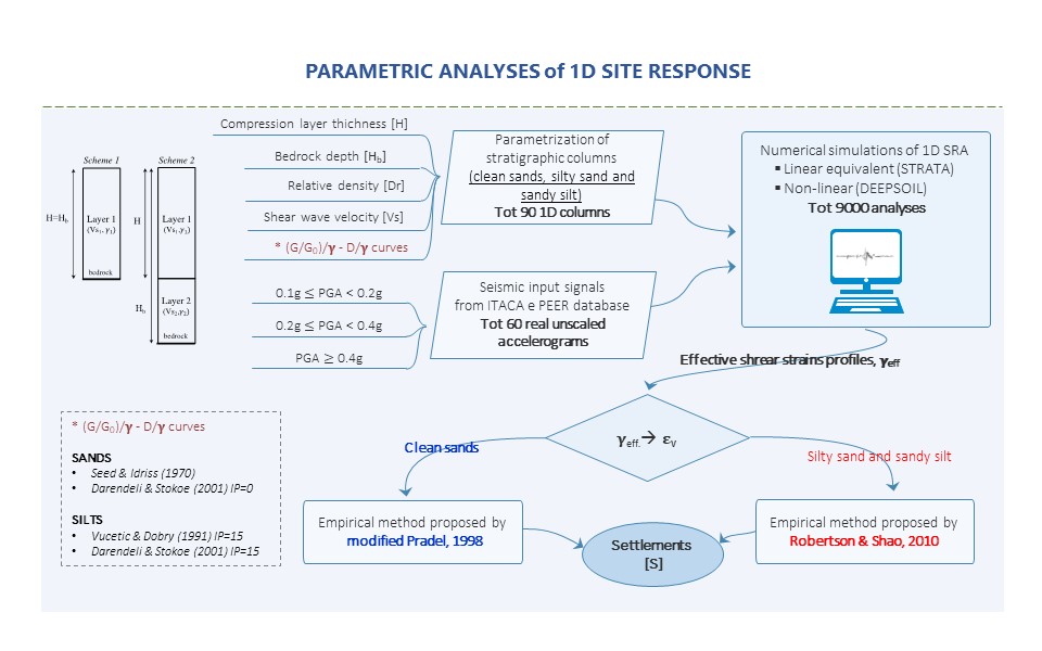
The susceptibility to this co-seismic instability in presence of dry clean sand, silty sand and sandy silty has been evaluated in the present work through the evaluation of the expected permanent ground settlements by means of non-simplified uncoupled methods computing volumetric strains from cyclic shear strains evaluated by means of site response analyses. This procedure was integrated into a parametric study of 1D seismic site response analyses varying relative density (or shear wave velocity) and thickness of compressible layers, intensity of input ground motion, depth of the seismic bedrock. The results have been then processed to define simplified charts differentiated for three different levels of input peak ground acceleration values and for the three considered lithologies (clean sands, silty sands and sandy silts).
These latter are mainly finalized to be used at urban scale, in the perspective of Seismic Microzonation (SM) studies requiring input-data commonly available in level 2 and 3 studies that have a strategic application in land use planning in the perspective of the territory protection.
A specific methodology was proposed by means of guideline based on a procedure with increasing complexity: 1) preliminary screening; 2) level 1 analyses; 3) level 3 analyses. The areas potentially susceptible to seismic compression identified in this preliminary phase are to be studied in the level 1 of SM, that identifies attention zones by checking the presence of predisposing conditions to the phenomenon. In the level 3 of SM, the susceptible zones and respect zones are identified through the estimation of the settlements by means of the charts proposed in the present work and the seismic site response analysis, respectively.

Parole chiave

CONTRATTO CONCERNENTE L’AFFIDAMENTO DI SERVIZI PER “PROGRAMMA PER IL SUPPORTO AL RAFFORZAMENTO DELLA GOVERNANCE IN MATERIA DI RIDUZIONE DEL RISCHIO SISMICO E VULCANICO AI FINI DI PROTEZIONE CIVILE NELL’AMBITO DEL PON GOVERNANCE E CAPACITÀ ISTITUZIONALE 2014-2020”– CIG 6980737E65 – CUP J59G16000160006
Copyright © 2017 - Progetto grafico e sviluppo Heap Design